Project Overview
This project aims to develop data collection techniques and data processing algorithms for constructing ultra-high resolution three-dimensional maps of outdoor landscapes. Existing technologies in remote sensing using satellites and aircraft provide data with limited spatial and temporal resolution (via the high-costs of data collection) that limit their effectiveness in small-scale environmental science and ecology studies. This project thus aims to develop low-cost data collection techniques using platforms such as kites and tethered balloons along with novel image-based data fusion algorithms for constructing high resolution 3D landscape maps for use in applications such as island geomorphology and coastal ecology.
Low-cost platforms such as kites and balloons are an alternative means for collecting data over small areas and have been used for aerial photography, for example in agriculture, ecology, humanitarian applications and archaeology although typically to acquire a single or a small number of photographs. Research has focussed on fusing information from hundreds and potentially thousands of overlapping photos using modern photogrammetry and bundle adjustment techniques, allowing for coverage over much larger areas with high-resolution and the recovery of 3D terrain topography.
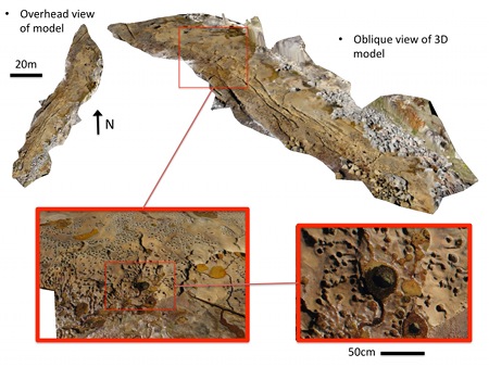
The techniques developed are applicable to a large range of applications including coastal beach and shoreline surveys, vegetation surveys, archaeology and the study of intertidal ecosystems. Current work in the intertidal domain has focussed on providing two types of information of interest for the study of intertidal ecosystems with a high level-of-detail over large areas that would be infeasible using traditional sampling methods. Topographic mapping allows for high-resolution measurements such as rugosity, vertical position on the shore with respect to tides and the slope and aspect with respect to the sun over a large area. Photographic mapping allows for the identification of intertidal species present during imaging and has the potential to provide data on variables such as species abundance and chlorophyll/ algal biomass with the addition of near-infrared images.
Project People: Mitch Bryson, Matthew Johnson-Roberson, Richard Murphy, Daniel Bongiorno, Stephanie Duce, Dan Harris, Jody Webster, Alisha Thompson, Ana Vila-Concejo, Stefan Williams.
M. Bryson, S. Duce, D. Harris, J.M. Webster, A. Thompson, A. Vila-Concejo and S.B. Williams, "Geomorphic changes of a coral shingle cay measured using Kite Aerial Photography", Geomorphology, vol. 270, pp. 1-8, DOI:10.1016/j.geomorph.2016.06.018, 2016. [online]
M. Bryson, M. Johnson-Roberson, R. J. Murphy and D. Bongiorno, "Kite Aerial Photography for Low-Cost, Ultra-high Spatial Resolution Multi-Spectral Mapping of Intertidal Landscapes", PLoS ONE 8(9): e73550. doi:10.1371/journal.pone.0073550, 2013. [online] [data]
M. Bryson, M. Johnson-Roberson and R. Murphy, "Low-cost, Ultra-high Spatial and Temporal Resolution Mapping of Intertidal Rock Platforms", Congress of the International Society for Photogrammetry and Remote Sensing (ISPRS), Melbourne, Australia, August 2012.
This project is supported through the Early Career Researcher Development Scheme through the Faculty of Engineering and Information Technologies at the University of Sydney.